

Waiau Track (St. Arnaud - Boyle Village)
Day 16: St. Arnaud to Lake Angelus Hut, 12.3km, 1250m uphill
Physical condition: 8/10
Mood: 10/10
After the major rainfalls and heavy flooding in the last two days, the sun finally made her way through the clouds again. A last coffee at the really nice Alpine Lodge and off we went. Soon a hitch with a really nice Kiwi was found, taking us up hill to the trailhead. The track to the famous Angelus hut, a highlight of the Nelson lakes nationalpark is not part the official TA track. Since we did not want to miss out this beautiful place, we'll be hiking on a different track the next two days and join the TA later on again. Today our track climbed up onto the Mount Robert ridge, following it into an amazing, alpine scenery at 1600m. We were completely stunned by this wild and rough landscape - so far the best day of the tour! The weather started off very fine, only a few showers were supposed to go down in the afternoon. As we were on a high altitude, they turned into snowfall. We had lots of fun, walking in shorts through snow showers and were finally welcomed by a snowman at the amazing Lake Angelus hut.
Nach den massiven Regenfällen in den letzten beiden Tagen, ließ sich die Sonne endlich wieder blicken. Leider stecken wir gerade in einer ziemlich ungünstigen Wetterlage, die uns ein starkes Regentief nach dem anderen schickt. In der Mitte ist dann immer wieder ein einzelner Sonnentag aufzufinden. Die Challenge auf dem nächsten Abschnitt wird sein, diese Tag mit den technisch anspruchsvollen Tagen
zu füllen. Der Weg heute führt uns entlang des Bergrückens hinauf und später entlang des Grates durch eine wunderschöne, wilde, hoch-apine Landschaft. Die Sonne war heute ein stetiger Begleiter, die die Gipfel atemberaubend in Szene setzte. Erst für den Nachmittag waren vereinzelt Schauer gemeldet, die sich in Anbetracht der Höhe verrückterweise in Schneeschauer verwandelten. In Shorts im Hochsommer in einen kleinen Schneesturm zu kommen ist auch ein Highlight. Die Hütte mit ihrer spektakulären Lage direkt am See umgeben von 2500er Gipfeln war wirklich großartig.
Day 17: Lake Angelus Hut to West-Sabine Hut, 25km, 800m uphill
Physical condition: 8/10
Mood: 8/10
Got up at 5:30am, since heavy rain was forecasted starting in the afternoon. While we had our breakfast we watched a stunning sunrise, dipping the lake and the surrounding mountains into pure gold. The first section went uphill, scrambling over boulders towards a pass. On the other side a steady decline along the ridge line awaited us. After reaching the bush line at 1400m the scenery changed into a incredibly steep and slippery path through beech forest. The track was soaked from the last rain, so we rather slipped than walked down the 1400m. When slipping too much, a tear or two may have dropped. At 12:30pm we finally reached Sabine hut, but decided to move on, since the weather forecast is very poor for tomorrow and with rising water levels we might not be able to do this section. With a five hours track ahead of us the mood was not only happy. After we started, the track was pleasant to walk in the beginning. But after 30 minutes the rain set in and the track condition steadily decreased. Due to the flood last Wednesday some parts of the track, which were close to the roaring Sabine River were washed away, forcing us to find a new route. Other parts were flooded. The last two hours were very tiring as the bad path conditions forced us to move very slowly. After 5,5 hours without a real break we finally reached West-Sabine Hut, completely soaked and cold. Tomorrow we'll have a weather-forced rest day while trying to dry our clothes. All in all, this was a very rough day with harsh conditions, but there is great joy when arriving in a warm and cozy hut. It is also surprising how well the body can cope which such exhausting days. It is always good to know that in the worst case we can keep going for quite a while. Very tired but happy we'll have a good sleep now and sleep until tomorrow morning.
Um 5:30 klingelte der Wecker. Das frühe Aufstehen wurde schnell belohnt, denn die Sonne begrüßte uns mit einem Sonnenaufgang, der die Berge in tiefes Gold tauchte. Am Morgen führt der Weg über große Geröllfelder hoch auf einen Sattel und auf der anderen Seite auf dem Bergrücken Richtung Tal. Nachdem wir die Baumgrenze erreicht hatten, ging der Weg super steil durch einen Wald bergab. Leider hatte der Regen den Boden so stark aufgeweicht, dass die ganze Angelegenheit eine ziemliche Rutschpartie wurde und wir den Boden immer wieder küssen dürften. Boah, das war hart. Nach 6 Stunden und 1400m bergab erreichten wir die Sabine Hut. Da die Wettervorhersage für morgen so miserabel ist, entschieden wir uns schweren Herzens noch weiterzulaufen. Vor uns lagen weitere 5 Stunden entlang des Sabine Rivers, diese ließen uns nicht gerade vor Vorfreude in die Luft springen... und sie waren auch entsprechend hart. Nach einer halben Stunde setzte der Regen ein und wir kämpften uns durch den dichten Wald entlang eines tobenden Flusses, der während der Flut am Mittwoch Teile des Weges mit sich genommen hatte und uns zwang, neue Routen zu finden. Nach weiteren 5,5 Stunden erreichten wir völlig durchnässt und kalt die lang ersehnte West-Sabine Hut. Auch wenn solche Tage wirklich super anstrengend sind und man sich immer wieder fragt, warum man das eigentlich macht, ist man abends glücklich, stolz und zufrieden. Ich finde es Wahnsinn, zu was der Körper in der Lage ist. Ich weiß aber auch, dass man gut zu seinem Körper sein muss, daher passt es gut, dass uns das Wetter zu einem Ruhetag morgen zwingt. Gute Nacht!
Day 18: Weather-forced rest day a the West-Sabine hut
Physical condition: 7/10
Mood: 9/10
Rain is pouring down again and we are having a very cozy, fun rest day at the hut playing cards, reading and eating. Eating actually developed itself towards our favourite topic. We are always hungry. Unfortunately, food is very limited here, since we have to carry it all. But you start to live with these restrictions. For beakfast we normally have oats for the first three days of the trip. It's nice to have something warm in the morning, but they are too heavy to carry for 8 days. After they're finished, we have musli bars (rich ones with quite a lot of calories), 2 per person. Additional 2-3 bars we eat as a snack during the day. For lunch we eat two wraps with peanut butter and jelly and for dinner some hot meal such as backcountry food or ramen noodles with freeze dryed peas and instant potato mash (that meal is called hiker's trash, you can even add some peanut butter). As a extra snack we also carry some chocolate and nuts. Still, it is probably not enough energy, but it is the maximum we can carry. Here a list of the food we carry on 8 day trip.
400g Oats mixed with protein powder and freeze dryed fruits
32 musli bars for breakfast + 24 bars as a snack
36 wraps
1kg peanut butter
350g jelly
7 backcountryfood a 250g
2x Ramen noodles
200g instant mashed potatoes
100g freeze dryed peas
2 chocolates a 190g
300g nuts
Tomorrow we still expect some rainy weather, but we'll move to the next hut. It's only a four hours walk. From there we'll be in a good position to hit the Waiau Pass, a highlight of the Te Araroa, once the sun comes out on Tuesday.
Der Regen peitscht gegen die Fenster, aber hier drinnen ist es dank des Feuers schön warm. Wie schön es im warmen Schlafsack ist und wir können einfach liegen bleiben. Toll! Tagsüber spielen wir Karten, lesen, dehnen uns und essen. Essen hat sich in den letzten zwei Woche zu einer Lieblinsbeschäftigung entwickelt. Da wir das Essen mitnehmen müssen und alles tragen, ist es strikt berechnet und limitiert. Manchmal ist das schwer zu ertragen, wenn der Hunger mal wieder viel zu früh zuschlägt. Zum Frühstück gibt es immer die ersten 4 Tage Oats, welche toll sind, weil sie warm sind. Leider sind sie aber auch recht schwer, sodass es die restlichen Tage je zwei Müsliriegel, um genau zu sein Hafervoll, mit vielen Kalorien gibt. Zum Mittagessen gibt es Wraps mit Erdnussbutter und Marmelade und zum Abendessen ein warmes Gericht wie zum Beispiel Instant Asianudeln mit gefriergetrockneten Erbsen und Instant Kartoffelpüree. Generell haben wir noch Nüsse und Schokolade als Snack dabei. Erdnussbutter ist allerdings der "Energy Hero", denn nur ein Löffel gibt einem gefühlt nochmal Energie für weitere 2-3 Stunden.
Hier einmal eine Liste was wir für einen 8 Tagestrip eingepackt haben:
400g Oats gemixt mit Proteinpulver und gefriergetrockneten Früchten
32 Müsliriegel als Früstück + 24 Riegel als Snack
36 Wraps
1kg Erdnusbutter
350g Marmelade
7 Backcountryfood a 250g
2x Ramen Nudeln
200g instant Kartoffelpüree
100g gefriergetrocknete Erbsen
2 Schokoladen a 190g
300g Nüsse
Morgen erwarten wir weiterhin regnerisches Wetter und werden nur 4 Stunden zur Blue Lake Hut laufen, um uns in eine gute Ausgangsposition für den Waiau Pass zu bringen, ein Highlight des Te Araraoa.
Day 19: West -Sabine hut to Blue Lake hut, 8km, only 3 hours
Physical condition: 9/10
Mood: 9/10
Today we had a short day, since the weather was still quite rainy and the next section via the Waiau pass asks for good conditions. So we had a short 3h stroll further up the Sabine River passing through beautiful mossy forests, open spaces and white water river sections. Just before we arrived at the hut, the sun broke through the clouds. Maybe we should have walked on, but then we decided to stay one more night here and to do the pass under exellent conditions tomorrow. However, some other Te Araroa hikers have been at this hut for two days waiting to pass and 5 more arrived after us. In total that makes 19 people in a 16 bunk hut, planning to do the trip tomorrow. We will get up early since it'll be a long day and we want to see the sunrise up in the mountains! But still, no need to rush. By the way, tonight's hut is located next to the Blue Lake with the clearest fresh water in the world. Visibility reaches up to 70m!
Heute war nur ein kurzer Tag. Es war immer noch regnerisch und der nächste Abschnitt des Te Araroa, der Waiau Pass erfordert gute Bedingungen und ist dazu einer der schönsten Wanderwege. Wir folgten dem Weg durch atemberaubende Mooslandschaften und weiter hoch dem zurzeit sehr wilden Sabine River. Kurz bevor wir klitschnass in der Hütte ankamen, brach der Himmel auf und die Sonne zeigte sich von ihrer schönsten Seite. Einige andere Te Araroa Wanderer warteten hier bereits seit 2 Tagen auf schöneres Wetter, um den Waiau Pass zu überqueren. Am Abend hatten sich dann 19 Wanderer in der für 16 Leute vorgesehenen Hütte eingefunden, um morgen früh loszustarten. Da es ein langer Tag werden wird und wir den Sonnenaufgang gerne etwas höher in den Bergen miterleben möchten, werden wir morgen früh unterwegs sein. Unsere Hütte heute Nacht liegt mit Blick auf die schneebedeckten Berge an dem sogenannten Blue Lake, der das klarste Wasser der Welt hat. Die Sichtbarkeit unter Wasser ist bis zu 70m weit!
Update:
At 9:30pm a NOBO (north bounder) came into the hut, telling us, that the route is so dangerous and we would set our life at risk. Everyone was confused and did not have a good sleep at night, being worried. We decided to start a little bit later and to take it easy.
Gegen 21:30 kam noch ein NOBO (Richtung Norden laufender Wanderer) an, der völlig erschöpft berichtete, wie schwer die Etappe sei. "Ein falscher Schritt und man ist tot." Außerdem seien die meisten Campingspots mit der Flut weggerissen worden. Diese Neuigkeiten raubte vielen, der 19 SOBOs, inklusive uns, wohl einige Stunden Schlaf. Jedenfalls entschieden wir uns entgegen vorheriger Planung die erste Gruppe an Wanderern schon mal los ziehen zu lassen und den Pass gemächlich anzugehen.
Day 20: Blue Lake Hut to Upper Waiau Forks, 7km, 1000m up, 7 hours
Physical condition: 8/10
Mood 10/10
When we got up, the sun was out (YES!). The night in the hut was quite cold and oats warmed us off again. At 7:45 am we started walking towards Lake Constanze. After passing the lake on the true right we followed the valley further up, than the track climbed (straight!) up to the pass. Wow, that was tough. Still, we start being in quite good shape and did pretty well. And honestly, it was tough but not seriously dangerous in any place. We don't know what this guy meant and we should rather have slept than listend to him. The weather condition were perfect and payed us of with stunning views. From there we climbed down into the Waiau Valley and soon found a really nice camp spot. We decided to stay here, the others are supposed to be washed out. In total it was one of our favourite days so far, short but very intense! Tomorrow will be less fun: rain and a long day ahead....
Als wir aufwachten, ging der erste Blick Richtung Fenster - Sonnenschein! Die Nacht in der Hütte war relativ kalt, wir waren ja auch schon auf 1200m Höhe. Schnell noch ein paar warme Oats gegessen und schon ging es auf zum Waiu Pass und Lake Constanze. Der Wasserstand des Lake Constanze war etwas höher als normalerweise, deshalb waren Teile des Wanderweges im See verschwunden, was aber neben etwas Kraxelei keine größeren Schwierigkeiten darstellte. Teilweise war der Weg ziemlich steil und ging meist über lose Geröllfelder, so auch der direkte Anstieg zum Waiu Pass. Allerdings war es wirklich nicht so gefährlich, wie uns der entgegenkommende Wanderer am Tag zuvor berichtet hatte. Die Wetterbedingungen waren wirklich grandios. Nach einem kurzen Abstieg waren wir auch schon bei unserem Zeltplatz angekommen. Dieser Tag gehörte wohl zu den Besten bisher, kurz aber sehr intensiv! Morgen wird's wahrscheinlich etwas weniger spaßig, der Wetterbericht sagt viel Regen voraus.
Day 21: Upper Waiau Forks, 36km, 8h15mins time in movement
Physical condition: 8/10
Mood: morning 5/10, afternoon 9/10, total 7/10
Wow, what a day! This has been by far the longest distance we ever walked in our life in one day. As the we both were awake at 5:30 am we decided to pack our stuff and start the day, since it wasn't raining at the moment and our tent was still dry. Setting of at 6:00am, heavy rain started at 8:00am. After a few minutes we were soaked and only a very disgusting Biwak (Caroline's Creek) was in a reachable distance. We sat in there for about ten minutes, being unsure about what to do. Since we were wet already we decided to walk on and go as far as possible. While the rain was pouring, visibility got worse and the track was washed out in many places. At the point where Julia was just about to tell Hauke, that she doesn't want to go on like this, the sun came through the clouds. Out of the sudden the thick cloud layer broke and we were in full sun. From there on we were able to enjoy the beauty of the landscape. We hiked down a wide and open valley, while Alpine mountains turned into roundly shaped hills, as you might know it from all the New Zealand pictures. Now the track was very easy going, mostly flat and very easy to stroll on. After the longest day on track, the most beautiful, recently installed Anne hut awaited us - what a treat!
Wahnsinn, was für ein Tag. Heute sind wir wahrscheinlich so viel gelaufen, wie nie in unserem Leben zuvor. Nachdem es die ganze Nacht sehr stürmisch, aber einigermaßen trocken geblieben war, entschieden wir uns um 5:30 unsere Sachen zusammenzupacken und loszugehen. Um 8:00 setzte starker Regen ein und wir waren bereits nach ein paar Minuten vollkommen durchgenässt. Wir suchten in einem kleinen Biwak auf dem Weg Unterschlupf, um zu überlegen, was wir als nächstes machen sollten. Schließlich entschieden wir uns dafür, erst einmal weiterzulaufen, denn nass waren wir ja immerhin jetzt eh und viel schlimmer konnte es nicht werden. Der Regen von den Vortagen hatte bereits einige Teile des Wanderwegs weggespült, was aber keine besonderen Probleme darstellte. Um 11:00 war Julia bereits kurz davor, Hauke zu sagen, dass wir so nicht weiterlaufen könnten, da brach auf einmal wie aus dem Nichts die Sonne durch die Wolken.
Das war dann der Start in einen wirklich tollen restlichen Tag und wir konnten bei bestem Wetter die schöne Landschaft genießen. Der Wanderweg folgte dem Waiau River durch ein immer breiter werdendes Tal und die Alpine Landschaft entwickelte sicher mehr und mehr zu einer hügeligen Landschaft. Der Weg wurde nun immer flacher und perfekt, um einfach mal ein wenig Strecke zu machen. Am Ende eines sehr langen Tages erwartete uns die Anne Hut, die schönste Hütte bisher, welche erst kürzlich erbaut wurde - eine schöne Belohnung!
Day 22: Anne hut to Boyle Flat hut, 17km
Physical condition: 6/10
Mood: 7/10
In the morning we sort of slept in to give our body at least a couple of hours to recover. But still, moving is quite painful today. We left the hut at 9:30 am. The track followed down another valley, passing Anne saddle at 1139m and further down. We could have walked out to Boyle village today, but Hauke had some pain in his Achilles' tendon today and generally were out of power after yesterday, therefore we decided to stay in Boyle flat and spent the afternoon playing "Doppelkopf".
Am Morgen schliefen wir ein wenig aus um unseren Körpern zumindest etwas mehr Regenerationszeit zu geben. Trotzdem war der Start um 9:30 Uhr recht schmerzhaft. Der Weg folgte einem weiteren Tal, über den Anne Saddle und dann weiter flussabwärts. Vermutlich hätten wir auch noch nach Boyle Village laufen können, dem Abschluss dieser Section, aber nun hatte Hauke Achillessehnenschmerzen und generell waren wir recht ausgepowert vom vorherigen Tag. Den Nachmittag verbrachten wir also lieber mit Doppelkopf spielen.
Day 23: Boyle Flat hut to Boyle Village, 14,5km
Physical condition: 5/10
Mood: 7/10
Today we want to hike out of here. Unfortunately, the rain that set in yesterday afternoon kept pouring all night and still keeps going. At 11:30am we decided to move, since the clouds seem to clear up. And we were right, we did not get wet! The track follows the river down the valley. Unfortunately, Hauke's Achilles' tendon still gives him a hard time. While passing some cows (first sign of civilisation after 8 days!) the track widens and finally leads us towards the Outdoor Education Center Boyle. While the sun is becoming stronger, we spend the afternoon in the garden, enjoying pizza and coke and a hot shower! In the evening, Haukes pain is suddenly gone and he is feeling good again. Since the weather forecast for the next two days is pretty good, we decide to move on tomorrow.
Haukes Achillessehnenreizung ist leider immer noch sehr schmerzhaft. Trotzdem wollen wir heute bis zum Ende dieses Abschnitts nach Boyle laufen. Leider regnet es schon seit gestern Abend durchgehend. Als um 11:30 zum ersten Mal die Sonne durch die Wolken bricht, entschließen wir uns sofort loszugehen. Der Weg folgt dem Fluss entlang durch das immer weiter werdende Tal, vorbei an Kuhherden und durch matschige Wälder. Schließlich kommen wir gegen Nachmittag am Boyle Village Education Center an und genießen bei Sonnenschein unsere wohlverdiente Pizza und Cola, sowie eine heiße Dusche. Am Abend sind Haukes Schmerzen dann plötzlich wie von Geisterhand verschwunden. Da der Wetterbericht für die nächsten 2 Tage viel Sonne vorhersagt, entscheiden wir uns morgen direkt weiterzulaufen Richtung Arthur's Pass.
 |
| Mount Robert Ridge |
The track up the Mount Robert ridge towards Angelus Hut.
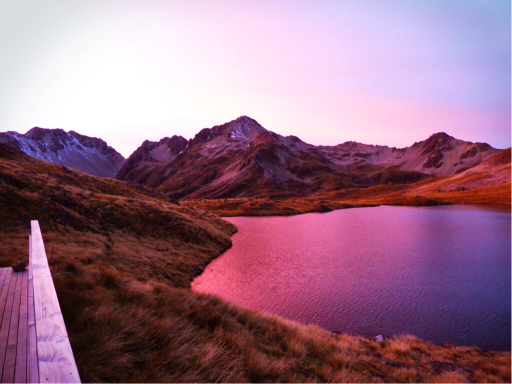 |
| Lake Angelus Hut View |
Lake Angelus at sunrise
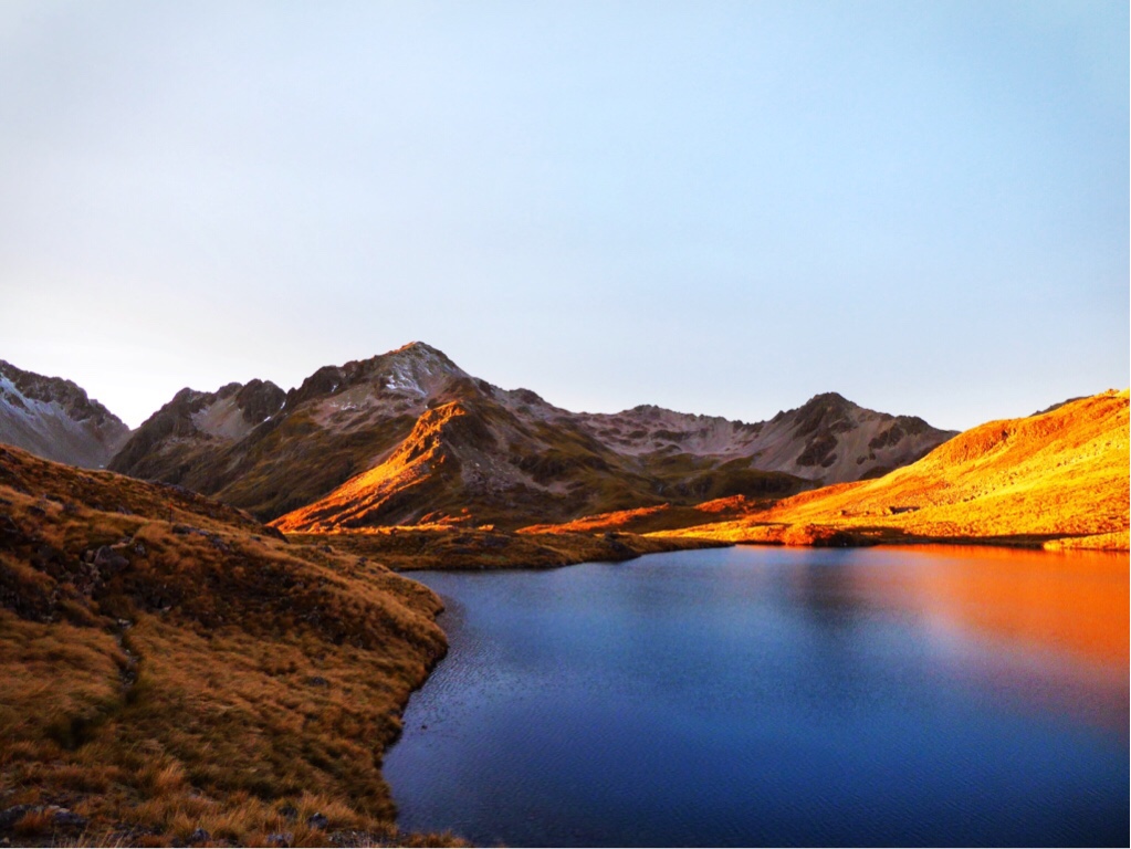 |
| Lake Angelus Hut View |
Lake Angelus at sunrise a bit later
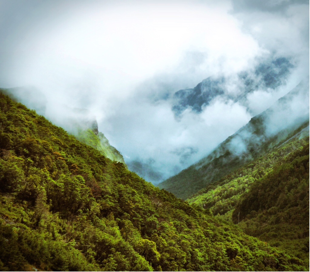 |
| Sabine River valley |
Sabine River valley
 |
| Sabine River valley |
Sabine River valley
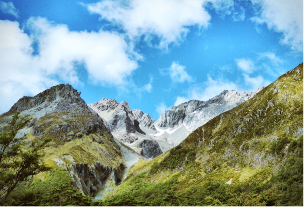 |
| Scenic mountains up at Lake Constance |
Scenic mountains up at Lake Constance

Made it to the Waiau Pass
 |
| Waterfall in the Waiau valley |
Waterfall in the Waiau valley
 |
| Waiau valley 4WD track |
Further down in the Waiau valley, sun is out again!


0 Kommentare: